There is almost 1000km of road from Churchill Falls to the ferry crossing to Newfoundland at Blanc Sablon, most of which is dirt packed. A lot of focus was placed on road conditions during this part of the trip - for good reason. Driving on winding gravel roads is a challenge and not for the faint of heart!
Trucks rush past at more than 100 km/hour, sending enormous rocks flying in all directions. Stones as large as small mountains stick out of the ground, just waiting to puncture the tires. Gigantic potholes the size of small lakes rattle the car and the nerves. Gravel that seems to think it knows where you want to go, desperately grips your tires and pulls the car towards enormous cliffs on both sides of the road.
A couple of tips we picked up along the way:
Drive fast. Seems counterintuitive but it works (somewhat). The car seems to fly over the rocks and holes instead of taking air over each stone and crashing through each pothole.
Slow down when a truck approaches, especially in Quebec where they seem to drive extra fast, in order to lessen the impact of the rocks hitting the windshield.
Don't try to speed up too much on an uphill as the gravel becomes especially tenacious and grippy.
Don't make too many sound effects. The passengers almost certainly feel like they are on a roller coaster ride that just might go off the tracks and discomforting sounds from the driver are likely to add a heightened sense of danger.
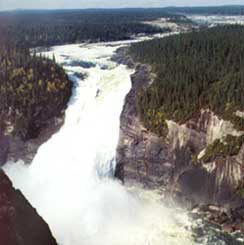
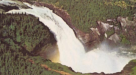
The most beautiful stretch of road in all of Labrador
North West River
At the Labrador Interpretation Centre in North West River we learned about the Innu and Inuit aboriginals, who have resided in Labrador for over 6000 years. In 1743, fur trader Louis Fornel established the Northwest River settlement. This was the beginning of the fur trade between Europeans and aboriginals in the area and it encouraged new settlers and Métis to populate the region.
Beautiful scenery at a lookout in North West River
North West River Beach
Happy Valley-Goose Bay
We spent the night in a campground in Happy Valley-Goose Bay, where the kind landlady warned us of wandering bears. Her advice for what to do if a bear started sniffing around? Get into the car and lean on the horn. Yes, we thought, but first you have to get from the tent to the car, past the hungry bear. Needless to say, we didn't sleep too well that night.
The scenery between Happy Valley-Goose Bay and Blanc Sablon changed dramatically as we drove south along the coast. From a sea of trees, the landscape changed to include open fields of grasses and later to undulating hills of green. The ocean began to appear in brief glimpses. The first iceberg we'd ever seen drifted slowly in the current.

Red Bay
A storm began to roll in as we entered Red Bay, an historic whaling community where Basque whalers returned year after year to exploit the abundance of whale oil, a source of light in Europe at the time.
A shipwreck, the ‘San Juan’, a Basque whaling ship, can be seen off the coast of Red Bay. At the Red Bay National Historic Site, artifacts from the shipwreck and the whaling community prove that Basque whalers did live and work in Canada at one time.
Blanc Sablon
Although the sun was shining by the time we left Red Bay, we followed the storm south to Blanc Sablon. We managed to catch the last ferry of the day to Newfoundland. A good thing too - the weather was so bad the next few days that all ferry crossings were canceled.
Read part one, part two, part three and part four of our trip.